Dates Keynotes Program Registration

The International Symposium on Mobile Mapping Technology (MMT) is the premier event traditionally jointly organized by the ISPRS, FIG, and IAG. The symposium has been organized on a two-year basis since 1997, when The Ohio State University hosted the first International Conference on Mobile Mapping Systems. 

MMT symposium is a major forum for discussing recent research and developments in mobile mapping technology, including systems and applications, providing a platform for international scholars, scientists, industry professionals, decision makers and students to exchange knowledge and share experiences on the most recent MMT developments. The continuing advancements of mobile mapping technology, remote sensing and geospatial information science greatly influence almost all aspects of geomatics surveying practice and have direct impact on our everyday life. The market share of mobile mapping, remote sensing, satellite imaging and geospatial information systems has significantly grown in the last decade and it is expected to increase even at a faster rate in the future.

The Symposium will cover the entire spectrum of the latest developments in mobile mapping technology, including research, algorithm implementation and system developments, ranging from land-based to airborne platforms, from direct georeferencing to sensor integration, from mobile data collection to dynamic GIS management, from positioning to mapping, from autonomous vehicles to drones, from data analitycs to artificial intelligence tools to support geospatial data understanding and interpretation, moving from post-processing to real-time operations. 

The Interdepartmental Research Center of Geomatics (CIRGEO) of the University of Padua is honored to host the 12th International symposium on Mobile Mapping Technology in Padua (Italy), on May 24-26, 2023

The day before the conference, a Mobile Mapping School will be also provided to those all who are interested to follow courses on this field.

Important dates

 Important dates
  • Very Early bird registration: 14 February 2023, 300 Euro
  • Early bird registration: 1 April 2023, 350 Euro
  • Late registration: After April 1 and on site, 400 Euro
  • Abstract submission: 1 March 2023 Extended to March 10! (Last extension)
  • Review results: 22 March 2023 *
  • Final Camera-Ready paper submission: 20 April 2023 Extended to April 30!

  • Mobile Mapping School: 23 May 2023
  • Mobile Mapping Technology Symposium: 24-26 May 2023

* Acceptance/rejection notification has not been sent yet for all the papers due to a delay in the review process. The  remaining notifications will be sent in few days, sorry.

Submission

Guidelines for Authors

All the accepted papers will be published in the ISPRS The International Archives of Photogrammetry, Remote Sensing and Spatial Information Sciences. Full papers should be submitted in accordance to the ISPRS Orange book guidelines. Publication on the ISPRS Annals is not envisaged. All the published papers should have at least one registration (uniquely) associated.

Authors should submit an abstract by sending it via email to mmt2023it@gmail.com. The scientific committee encourages the authors to submit extended abstracts (2-3 pages) in order to ensure a more reliable evaluation of the paper in the review process. Abstract file size should not exceed 25 MB.

Special issues related to the congress will be arranged on high rated international scientific journals.

Full paper Word template.

Full paper LATEX template.

Papers published on ISPRS Archives are now available - click here!

Topics

Topics

The MMT 2023 topics include but are not limited to:

  • Mobile Mapping Technology (system components, platforms, etc.)
  • Mobile Mapping applications
  • Sensor calibration (orientation, integration, reliability)
  • Wireless positioning techniques
  • Image sequence processing
  • Automated and semi-automated image segmentation and object extraction/recognition
  • Direct Georeferencing
  • Large datasets: management, query and transmission 
  • 3D Mobile Mapping and GIS integration
  • LIDAR and SAR mapping systems
  • Estimation and optimization algorithms
  • Point cloud analysis
  • Object extraction/recognition
  • Simultaneous localization and mapping (SLAM) techniques 
  • Semantic and metric SLAM; and learning and optimization for robotics multi-sensor integration 
  • Multi-agent cooperative localization and mapping
  • BIM and Cultural Heritage applications
  • Underwater positioning and mapping
  • Development of new terrestrial, aerial, underwater mobile mapping solutions
  • Mapping in precision agriculture and forestry
  • Urban, infrastructure and environmental monitoring
  • Mapping in hydrology and geomorphology, climate changes, remote sensing applications

Keynotes

Keynotes

Cheng Wang

Xiamen University

“LiDAR Visual Localization in Urban Environments”

Daniele Perissin

Sarproz, RASER Limited

“Satellite SAR interferometry: past, present and future”

Norbert Pfeifer

TU Wien

“A Focus on the Trajectory in Lidar Mobile Mapping”

Mohamed Mostafa

Trimble Applanix

“Enabling Autonomy and Surveying by Direct Georeferencing”

Erica Nocerino

University of Sassari

“Underwater mobile mapping”

    Program

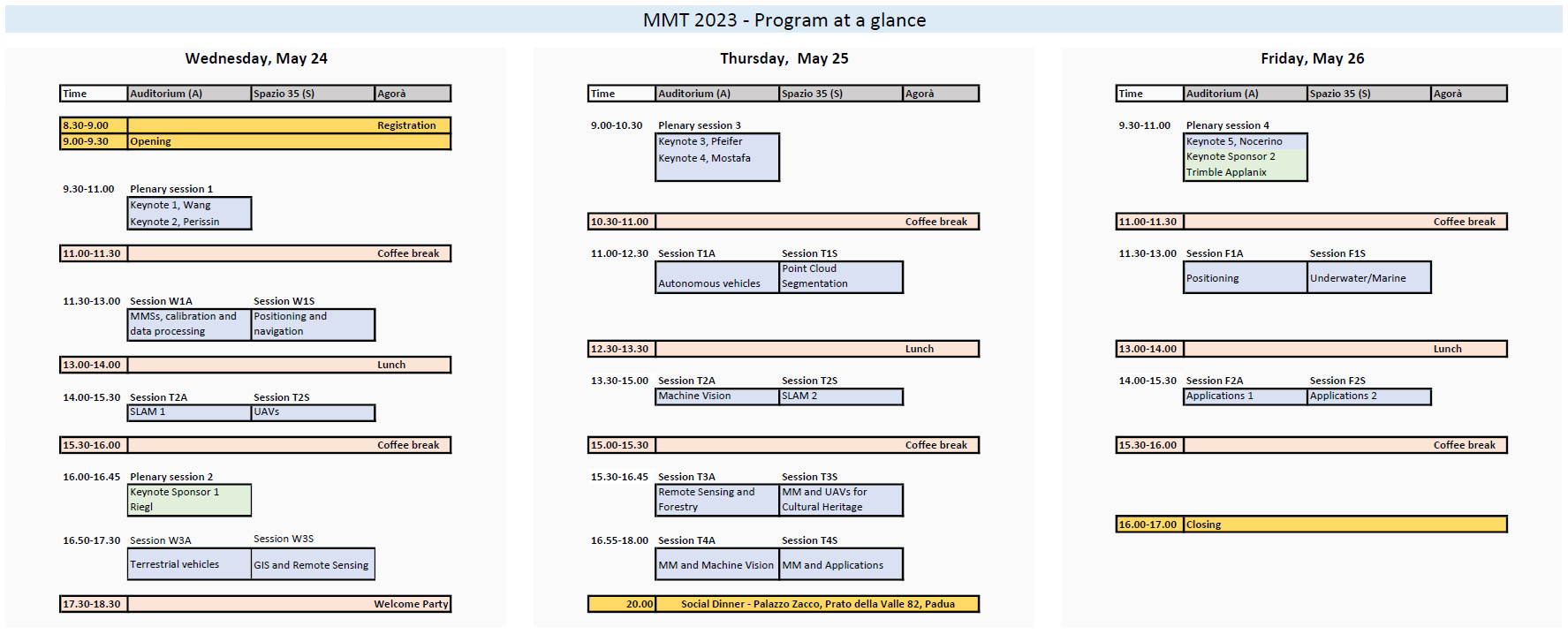
    Program at a glance (draft)

    Detailed program

    Social Dinner will be at 8.00PM on Thursday, May 25, at Palazzo Zacco, Prato della Valle. The restaurant has some dress requirements for who will come at the Social Dinner. Please, avoid jeans and sneakers. @men: blazer, or similar, and tie shall be worn.